River traces around Hualien, Taiwan
Filter Traces
-
Jay
River:
恰堪溪 / Qiakan creekArea:
HualienRegion:
EastStart:
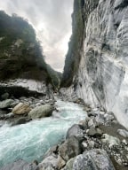
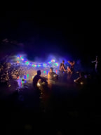
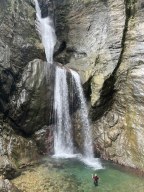
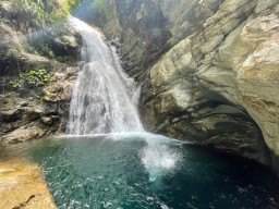
23.84323,121.41624Erzishan is a famous hot spring destination that stretches for hundreds of meters. Ranked as one of the ten most epic hot springs, Erzishan Hot Spring is located in Qiakan Creek, Hualien. The entire river tracing route takes about 4 to 6 hours and requires 10 to 20 river crossings. Due to the creek’s tendency to flood during rain, the hot spring can ... be difficult to access. -
River:
中平溪 / Zhongping creekArea:
HualienRegion:
EastStart:
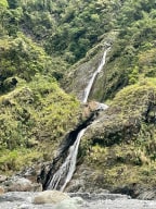
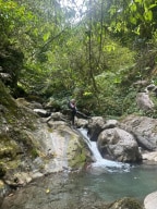
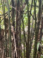
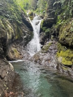
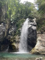
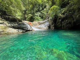
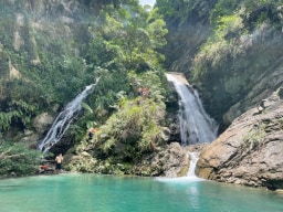
23.3871,121.29691We went to a tributary of Zhongping Creek (中平溪). We walked mostly on the hunting trail from the beginning to the fork, which took us two hours to reach and one hour to return. The trail was not easy to navigate because it was full of bushes. The creek is full of life. We saw a lot of fish, big crabs, and shrimp. We even saw a barking deer falling to ... ward us and running away. We also saw a goat on a slope, but it quickly fled. We were amazed by how much wildlife we encountered. We visited two waterfalls in the tributary. They were close to each other. The first one has a beautiful shape like the one in Qiedong Creek (茄苳溪) or Jianshanhu (尖山湖瀑布). We went up the waterfall by its right side (facing downstream). The bushwhacking was full of thorn vines—quite painful. We carefully climbed through bushes and thorn vines and set up a rope to climb back down to the creek. The second waterfall was just ahead of us. It was a 50-meter waterfall and looked very similar to 九龍瀑布 (Nine Dragons Waterfall) in Pingxi. If you trace up Zhongping Creek instead of its tributary, you might reach Valau Waterfall. It's giant and can be seen from satellite images. However, the trace takes 12-13 hours and requires skills and massive stamina. -
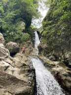
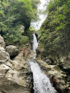
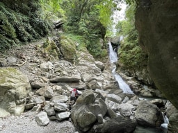
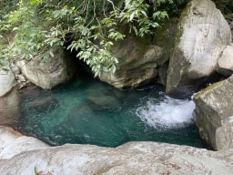
River:
馬鞍溪 / Ma'an creekArea:
HualienRegion:
EastStart:
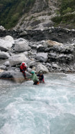
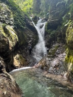
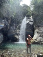
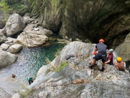
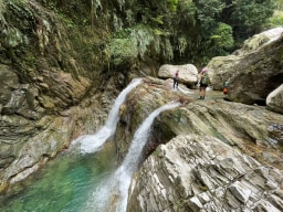
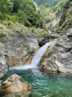
23.68982,121.37294A beautiful creek with a lot of climbing. We visited two waterfalls and a pool between them. The distance isn't long, but it took us a lot of time (eight hours in total). There's a third waterfall, but we didn't go there. Beginners will have a very hard time, but ordinary river tracers or people good at climbing should be fine. A rope is strongly r ... ecommended for this trip. We visited two waterfalls. The first one is quite beautiful, located in a half-encircled gorge. The second one is a three-tiered waterfall. Between the two waterfalls is a pool similar to Goddess' Pool in Melburry Creek (you need a rope here to make sure you can climb back after jumping in). -
River:
三棧溪 / Sanzhan riverArea:
HualienRegion:
EastStart:
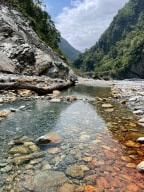
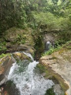
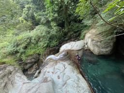
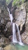
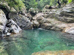
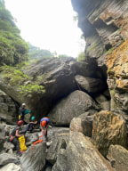
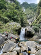
24.10787,121.59976The 5-kilometer one-way hike was quite long. We walked almost non-stop and chose to stick to the trail as much as possible while strictly limiting our time to 5 or 10 minutes at each large pool. To save time, we followed the trail for most of the route to Double Dragon Waterfall rather than tracing in the water. From Double Dragon to the final 120-m ... eter waterfall, the creek became steeper and more challenging, requiring us to climb large rocks, which slowed us down. There were no technical difficulties, but it demanded physical stamina and strict time management. We spent a fair amount of time at each large pool, but we decided to skip the Double Dragon pool and its slide. On our way back, we jumped into the pools (having checked their depth and suitable jump spots on our way up). We passed all the commercial tours and were rewarded with the opportunity to filter and drink the creek water, which tasted great. Most of them only reached the first large pool, and only a few made it to Crimson Gorge. Before reaching the final waterfall, we encountered a slender and elegant 60-meter waterfall and another tall one. Then came the enormous final 120-meter waterfall. It deserved a spot in my top ten magnificent waterfalls list, alongside the 120-meter Nenggao Soaring Falls. I had initially thought it would be around 70 meters based on the topo map, but I was glad to be proven wrong—very wrong. The waterfall consisted of three tiers, resembling the cross-section of a pork belly. The creek water from the main stream rushed from the top of the waterfall to the next tier, then further down to another tier before finally reaching the enormous pool it had created. The waterfall gorge had a beautiful shape, surrounded by steep mountainsides. A giant boulder served as the waterfall's threshold, which we had to climb over to access the pool, accompanied by a secondary 10-meter waterfall between the boulder itself and the giant pool. This trace was one of the most enjoyable and rewarding experiences I've had so far. It appears that there was another waterfall over 100 meters high about 300 meters away. Hopefully, someone can bring a drone to check it out. Trailhead 24.10787,121.59976 Rose Valley 玫瑰谷 24.11162,121.59199 Crimson Valley 赤金峽谷 24.11639,121.58093 Double Dragon 雙龍瀑布 24.11679,121.57702 Gorge 24.11692,121.57491 120-M Pork Belly Waterfall 24.12026,121.57353 -
River:
木瓜溪 / Mugua riverArea:
HualienRegion:
EastStart:
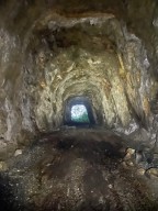
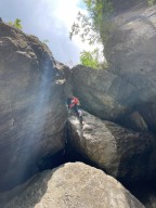
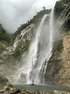
23.9882,121.45232Nenggao Soaring Fall is a difficult river tracing route that involves ascending 500 meters over a short distance of 700 meters. It's a continuous uphill climb. The route to Nenggao Soaring Fall is beautiful with numerous stunning pools along the way. The pools are clear and home to large fish, making it unlikely for anglers or locals to come fishing ... . Upon reaching the parking area, the entrance is located beside a tunnel, next to Taipower's steel fence. After crossing the stream, you will see Taipower's channel on the left bank of the tributary(facing downstreams). Follow this channel to the end (approximately 40 minutes), and you will reach a 30-meter waterfall. Below is a beautiful deep pool known as "Hualien Divine Pool," with a large, clear and gorgeous deep blue pool outside. There are stairs next to the waterfall that lead down to the pool. The journey to Nenggao Soaring Fall involves climbing and is moderately difficult (but definitely not suitable for beginners). The path is recognizable for experienced river tracing enthusiasts. The most challenging section is located 200 meters before the endpoint. Once you pass this section, you are almost at Nenggao Soaring Fall. This section features a challenging climbing hole with a slippery 2.5-meter large rock underneath. There is a 3-meter suspended drop to the hole's entrance, with no footholds available. You have to be able to squeeze yourself to the tiny hole above the drop. Many experienced river tracing teams have failed and turned back at this point. If your team doesn't have a skilled climber to set up ropes first, and teammates who can use rope equipment or at least have really good climbing abilities, it may be impossible to climb with a rope, not to mention without a rope. I used an additional climbing nut as a hand rope here. Without this extra hand rope, team members with limited climbing abilities still won't be able to climb up. On the return journey, rappelling is necessary. Even with a rope, it is impossible to descend without rappelling (unless you are an expert climber, but it is still highly dangerous). Fortunately, an anchor can be easily set here. Luckily, when we went, there was a high-hanging blue-green webbing and a rope, and many bolts were drilled into the rocks. However, climbing was still extremely difficult. The rope was hung on a rope-wearing edge, so I couldn't fully trust it. The blue-green webbing was much better, secured to a sturdy stone. If it hadn't been hit by other rocks, it should be solid, although I can't guarantee this after a typhoon. After walking for 10 minutes, the enormous Nenggao Soaring Fall comes into view. The awe-inspiring 120-meter waterfall has a massive flow of water rushing out of the top, leaping into the pool below. Its shape resembles flight, which is why it is called "Nenggao Soaring Fall" by the Japanese during the colonial era. The pool is large and suitable for swimming, but the waterfall's wind is extremely strong, making it feel like walking into a downpour. There is also a 140-meter waterfall above this waterfall, but it requires advanced summit tracing skills and a at least two-day expedition.